OpenStreetMap Ireland AGM and General Information Day

OSMI will hold its first AGM since forming a company to represent the community on the 15th of June. The event will be in two sections, starting off at 11am with a short introduction and a demonstration/tutorial for anyone new to open source mapping. After that, there will be a selection of five-minute lightning talks and general discussion up to the 1 pm break. Anyone interested in giving a talk can tweet the organisers @osm_ie.

Then around 2 pm, the formal AGM begins with a detailed report of the work being done behind the scenes. The board that formed the company will step down and hold a vote for the new board. This is an opportunity for anyone interested in joining to help with the administrative/behind the scenes work and help shape the future of how mapping progresses in Ireland.

There will also be an opportunity to join a working group, such as having every house on the island mapped or other high level project and system administration for back-end services.

OpenStreetmap Meetup and Mapillary Workshop on the 24th November from 11am to 3pm

Logo for Open Streetmao Ireland
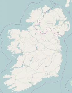
After OpenStreetMap Ireland’s successful launch as a company, it is time to get back into the swing of things and start mapping again. OSM is the Wikipedia of mapping where the users contribute to the map, either locally through direct observation, by satellite imagery or from in car-mounted cameras, on bicycles, etc, with Mapillary.

Bring a laptop and your mobile phone and learn about the various tools ranging from simple to expert, to edit the map. So no matter what your technology experience there is a way to contribute. One of the phrases from the launch was warm mapping, where people can add a soul to the place, instead of the cold formula used by the proprietary services. So let’s stay warm together in this cold winter season and map our communities!

There will be a 20min workshop in Mapillary, followed by a 40min walk around to put those skills to use (Warm jacket recommended). Could be useful for any new arrivals to Dublin!

Register your interest on Meetup.


OpenStreetMap Ireland OGM

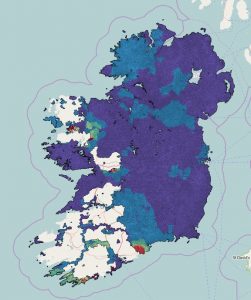
On Saturday the 28th of April, OpenStreetMap Ireland will be holding an OGM for all who are interested in knowing about our ongoing process to set up a company, that will represent the collaborative mapping of Ireland through OpenStreetMap. The interim committee will keep the community up to date with our progress so far, in what should be finished in a few months. This means the meeting will predominantly be about legal and administrative matters. This is your chance to talk with many of the interim committee members who will be present, during the midpoint in our work and raise any matters you may have or are simply curious about. We hope this will be the second last meeting before we can formally announce the creation of the company. One question that has been raised is “Why create a company to represent OSM Ireland?”. The answer is that part of the work members have done is to lobby government bodies to open data and bring it into the sphere of the citizen, where it can be used to improve our lives. On another occasion, a member was offered a grant to continue our work. To be able to accept money, lobby effectively, or any related task, we need to have a legal entity behind us. Which will, in turn, boost our ability to spread the benefits of open source maps for and by the people and not solely in the hands of large corporations or government bodies.

We are aware most members have a greater interest in actual mapping, so we hope to resume normal services by the end of summertime. We talked about doing a little mapping towards the end of the upcoming meeting. Perhaps a short walk around the area to submit some updates to OpenStreetMap. Or using some new tools like Mapillary or StreetComplete, this will depend on interest and who shows up.


Open Street Map Ireland AGM

On March 24th from 10am to 3.00pm Open Street Map Ireland will be have its first AGM to set up a formal organisation to cement what has been a loose collective of like minded individuals into a legal structure.

OSM is a worldwide mapping initiative, which is fully open source, i.e. made by people for other people, that anybody can contribute to with a low barrier to entry. There are a variety of tools to get you started, where you can shape the map you use with the detail you require, instead of hoping a proprietary solution will fit your need. There has been OSM activity in Ireland for well over a decade, with townland boundaries, coastline, cemeteries and monuments being mapped in earnest. Often newly opened roads get mapped as soon as the tarmac dries, historical building, paths, and other information not always included in official spatial data. Some areas areas need more detail, so there is still plenty to do.

Irish mappers have also greatly assisted the Kingdom of Lesotho to map and train their citizens in mapping their country, which not only saves them high costs, but empowers the people to be help themselves and use the open information to improve their lives. Anybody with an interest in maps is welcome. Find out more on Facebook, Twitter or the OSM Ireland mailing list.

Learn more at our Facebook page.